Activities That Make Geography Memorable
Exploring maps through games and discussions helps elementary students gain a deep understanding of relationships between places.
Your content has been saved!
Go to My Saved Content.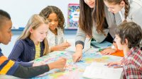
“Who can point to Peru? Here’s a hint: It’s in South America and shares a border with Brazil.”
One student stood up, studied the map, paused for a moment, and confidently pointed... to Argentina. It was a moment I had seen before. Students could remember individual facts, but using those facts to understand spatial relationships was a different skill.
I realized I had been treating geography as something students needed to memorize rather than understand. Memorization still had a place, but it needed to be connected to reasoning, observation, and real-world relationships.
To make geography more meaningful, I stopped asking students to simply identify locations and started giving them opportunities to solve problems, explain their thinking, and recognize patterns.
Using Engaging Activities to Deepen Geography Skills
Hands-on activities and geography games give students the opportunity to revisit places from different perspectives, strengthening their mental maps and helping them understand how the world is connected.
Puzzle Maps. To help students better understand spatial relationships, I gave them more opportunities to physically interact with maps. Puzzle maps—where students build a map by placing shaped pieces representing continents, countries, or regions—are common in Montessori classrooms, but the same approach can be adapted with printed or laminated maps.
Rather than asking students to label a completed map, teachers can have students rebuild maps by placing pieces in the correct locations and explaining their reasoning. This works best in small groups so that each student can place a piece and offer an explanation until the puzzle is complete.
If students disagree, they should be encouraged to use evidence from the map, such as neighboring countries, coastlines, or oceans, to support their thinking and ultimately decide where each piece belongs.
As students worked together on a puzzle map in my classroom, I would often hear them say things like “This country can’t go there because it borders the ocean” and “These two countries have to touch because they share a border.”
Because they were discussing the unique geography of each place as they worked to solve the puzzle, they were better able to build mental maps that lasted.
Pin the Location. Another way I encouraged students to interact with maps was through a game called Pin the Location. Students used pins labeled with country names, flags, capital cities, and landmarks to connect place names with locations on an unlabeled map.
But instead of simply asking students to place a pin in the correct spot, I turned the activity into a mystery challenge where students used clues to identify a location. I would reveal one clue at a time about the specific location I wanted students to label, and they would work in pairs to correctly place the pin on their map.
I would then have students share out their pin locations, and we would discuss as a whole group how students decided where to place their pins. Students used neighboring countries, oceans, mountain ranges, and other features to explain their choices.
Teachers can adapt this game in many different ways by varying the specific clues they give: Younger students might focus on continents, oceans, and directions, while older students can incorporate climate, landforms, population, or cultural characteristics.
What Location Am I? While this game is pretty similar to the Pin the Location activity above, it introduces a different format that allows teachers to rotate through these activities to keep students engaged. In this version, students work in groups of three to identify a location on a map based on written clues. One student reads the clue; another student identifies the location and explains their choice; and the last student checks the answer, which is written on the same card as the clues. Students then rotate roles.
For the activity to work, teachers need to prepare the clues in advance and ensure that each group has a blank map to work with. I like to put two to five clues on each card, depending on how difficult the location is to identify, and then the correct answer under the clues so that one student can check the location chosen for accuracy.
This activity can encourage more participation than Pin the Location, as each student is responsible for identifying a location and explaining their reasoning to the small group as opposed to working in pairs, where one student may dominate the conversation.
Additionally, students often really enjoy getting the chance to be the clue reader and the answer checker.
What Do You Notice? In this activity, students simply state things they notice and ask questions that they are wondering about in response to a map. Sometimes I would show an unlabeled map and ask students what they noticed about a specific location.
They might say things like “The country is really big” or “The country is close to the ocean.” Other times, I would project a population or elevation map of a continent, and students would begin to notice things and say things like “Why are there more people near the coast?” or “There are mountains in between those two countries.”
There were no correct answers that I was looking for from my students. Instead, I just prompted them to start thinking about how the specific geographic features of a location might impact the location and the people who live there. These conversations helped students see maps as tools for investigating relationships and understanding how geography influences people and places.
When students learn how to investigate maps instead of simply memorizing them, geography becomes more than a list of places—it becomes a way to understand the relationships that shape our world.